

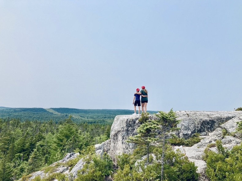


Years ago, we were looking for a way to fill a very long summer day with young kids. We found ourselves on Nova Scotia’s South Shore with no particular destination in mind when a well-timed Google search introduced us to the idea of hiking Castle Rock.
Castle Rock Trail turned out to be exactly what we needed: a mostly level hike through the woods, followed by a short but challenging climb onto a granite summit overlooking Mahone Bay.
That spontaneous decision was a good one! Everyone enjoyed the trail, and we made a mental note to come back and hike it again.
A few years later, we tried to repeat the same adventure but arrived to discover that recent heavy rains had washed out sections of the trail. It was temporarily closed.
In August 2025, we finally tried again. We debated heading to the beach for the provincial holiday but settled on a family hike instead, and I immediately tossed out the idea of returning to Castle Rock.
Our timing could not have been better. The following day, all wooded trails in Nova Scotia were closed because of the forest-fire risk.
John packed a picnic lunch, we grabbed hats, filled our water bottles and hit the road!
Important 2026 trail update: Sections of the Chester Connection Trail between Goat Lake Road and East River may close intermittently because of the Highway 103 twinning project. The work is scheduled to continue through December 31, 2026 and may affect access to Castle Rock. Check the Municipality of Chester’s current trail-construction notice before leaving home.
Table of Contents


Castle Rock Trail at a Glance
Location: East River, near Hubbards on Nova Scotia’s South Shore
Parking: East River Trail Parking Lot, 7846 Highway 329
Total distance: Approximately 8–9 kilometres return
Our recorded distance: 8.73 kilometres
Time: Allow approximately three to four hours
Difficulty: Easy and level for much of the approach; moderate to challenging near the summit
Dogs: Permitted but must remain on a leash
Open: Year-round, although there is no winter maintenance
Best feature: Panoramic views over Mahone Bay
Family-friendly: Yes for capable walkers, but the final climb is not suitable for strollers, people with mobility limitations or very young children
Where to Park for Castle Rock Trail
Our first stop was East River Picnic Park. It’s a handy little pull-off with several picnic tables, garbage facilities and an outhouse.
Why sit at a table when you can eat your sandwich and plum atop a large boulder, right?

Finding Castle Rock can be a bit confusing, so use East River Trail Parking Lot as your navigation destination rather than searching only for Castle Rock.
The parking lot is approximately 750 meters beyond the picnic area. It’s spacious and, when we visited, had a portable toilet on-site.
From there, it’s a short walk to the Aspotogan Trail Section, part of the Rum Runners Trail system that stretches from Halifax to Lunenburg. This leads directly to the Castle Rock Trailhead. (Here’s a printable map of the Castle Rock route including trail options and difficulty levels.)
This first portion is not merely a quick access path: it accounts for more than six kilometres of the total return hike. That is worth knowing before you set off!

What Is the Castle Rock Hike Like?
Most of the approach is along a wide, groomed and relatively level rail trail.
It’s suitable for walking and biking, and the surface is manageable for many strollers. You pass over wooden bridges, alongside water and through long stretches of forest.

Once you turn off the Chester Connection Trail and begin climbing toward Castle Rock, the experience changes quickly.
The trail becomes narrower and more rugged. There are rocks, exposed roots and steeper wooded sections to navigate. Sturdy footwear is helpful, especially if the ground is damp.
The final 100 metres involve scrambling up exposed rock to reach the summit. There are several colour-coded routes, ranging from easier grades to more challenging wooded climbs.
It is absolutely doable—but it is much more demanding than the wide rail trail leading to it. The official trail information also cautions hikers about steep rock faces and slippery surfaces

Is Castle Rock Trail Family-Friendly?
Yes—but with a rather large asterisk.
Most of the trail is very family-friendly. The Chester Connection portion is wide, level and easy to navigate. Children have space to walk ahead or dawdle behind without being squeezed onto a narrow path.
Reaching the Castle Rock summit is a different story.
Indy was approximately four years old the first time we completed the hike, so young children can do it. Still, I would only recommend the summit for children who are confident walkers and comfortable climbing over rocks.
A stroller could handle much of the rail-trail section, but it cannot reach the summit. That makes this an impractical stroller hike if your goal is to climb Castle Rock.
The summit also has steep exposed edges without barriers. Children need close supervision at the top, regardless of how capable they were on the climb.
The hike is not suitable for anyone with significant mobility limitations, and I would be very cautious about attempting the final section while carrying a baby or toddler.

Reaching the Castle Rock Summit
The final climb brought back all sorts of memories from our first visit.


Five years had turned Indy from just beyond the toddler stage into a tween, but several scenes looked strikingly familiar.
How does that happen so quickly?
The summit itself is a broad granite outcrop surrounded by forest. From the top, you can look across the trees toward Mahone Bay and its scattered islands.
It was a bit hazy during our latest visit, but the view was still stunning.
There is plenty of room to sit, have a snack and enjoy the scenery—as long as everyone remains mindful of the exposed edges.


Who’s ready for another throwback. At this stage in parenting, I could still pick her up and carry her on my hip.


And now we share clothing…


The kids were very keen to capture jumping shots, which is not my forte. But it was lots of fun and some of the facial expressions on outtakes were hilarious.


To get in-air shots, I took photo bursts and caught Indy sticking one landing. I think it looks like he’s declaring himself King of this particular Castle!

And then it was time to return from whence we came…

Which Castle Rock Route Should You Take?
There are several colour-coded routes leading through the wooded section and up to Castle Rock.
We took the more difficult Yellow/#3 route on the way up and the easier Red/#1 route on the way down.
I was not a huge fan of the Red route. Although the grade was easier, much of it followed a gravel road. The loose stones made the descent surprisingly awkward, although that route would have been more suitable for a bike.
The more technical wooded trail required extra concentration, but I preferred walking over roots and solid rocks to sliding around on loose gravel.
Your best route will depend on:
- Current trail conditions
- Your footwear
- The ages and abilities of your group
- Whether the ground is wet
- Whether you are hiking or biking
Download or photograph the trail map before setting out. Cell service should never be your only navigation plan in the woods!!!
Total distance for us 8.73 km.
What to Bring on the Castle Rock Hike
Castle Rock is not an extreme backcountry hike, but it is long enough—and the final section is technical enough—that a little preparation makes the day much more enjoyable.
Bring:
- Sturdy sneakers or hiking shoes
- Plenty of water
- Snacks or a picnic lunch
- Sunscreen and a hat
- Bug spray
- A light layer in cooler weather
- A downloaded or printed trail map
- A leash and waste bags if bringing a dog
I would also check current trail closures, wildfire restrictions and weather conditions before leaving home.
Castle Rock Trail is officially open year-round, but the trail is not maintained during winter. Snow, ice and wet rock would make the final climb substantially more difficult. Dogs are welcome but must remain leashed.
How Long Did the Castle Rock Hike Take Us?
My watch recorded a total distance of 8.73 kilometres and approximately two and a half hours of active walking.
That doesn’t include every stop for pictures, snacks, family negotiations and attempts to capture children in mid-air.
For most visitors, allowing three to four hours is sensible. Add more time if you are hiking with young children, planning a picnic at the summit or taking the more technical routes.
Is Castle Rock Trail Worth It?
Absolutely.
The long, level approach makes the hike feel manageable, while the final wooded climb adds enough difficulty to make reaching the summit feel like an accomplishment.
The view across Mahone Bay is a spectacular reward.
Castle Rock is a great choice for locals looking for a weekend adventure, visitors exploring Nova Scotia’s South Shore and active families hoping to spend several hours outside.
We finished our day with ice cream at the Falmouth Scoop, which has officially become one of our favourite stops for summer treats.
Huge servings, quality ice cream and unbeatable prices! There are worse ways to finish an almost nine-kilometre hike.


Frequently Asked Questions About Castle Rock Trail
How long is Castle Rock Trail?
The complete return hike from the East River parking lot is approximately 8.5–9 kilometres. Our watch recorded 8.73 kilometres.
How much time should I allow?
Plan for approximately three to four hours. Strong hikers could complete it faster, while families and anyone spending time at the summit may need longer.
Where do you park for Castle Rock Trail?
Park at the East River Trail Parking Lot at 7846 Highway 329 in East River, Nova Scotia. From there, follow the Chester Connection Trail for approximately 3 kilometres to the Castle Rock trailhead.
Is Castle Rock Trail difficult?
Most of the approach is flat and easy. The final wooded section is more technical, and the last 100 metres require a steep scramble over exposed rock.
Can children hike Castle Rock?
Capable children can complete the hike, but the final section is not appropriate for strollers or very young children. The summit has steep, unprotected edges, so close supervision is essential.
Are dogs allowed on Castle Rock Trail?
Yes. Dogs are welcome but must remain on a leash.
Is Castle Rock Trail open during winter?
The trail is officially open year-round, but it doesn’t receive winter maintenance. Snow and ice can make the summit climb considerably more difficult.
Planning more adventures around the province? You might also enjoy my guides to the best beaches in Nova Scotia, the best lighthouses in Nova Scotia and 48 hours on Nova Scotia’s South Shore.
Whether you’re a local looking for a new weekend adventure or visiting Nova Scotia and craving coastal views, Castle Rock is a fun hike. The trails are well-maintained and the summit offers spectacular views. It’s a great outing for anyone hoping to spend a few hours in nature!
Your turn.
- What’s the best high-level viewpoint in your town/city?
- Would you rather hike on groomed, flat trails, or navigate a more technically difficult wooded trail?
Discover more from The Optimistic Musings of a Pessimist
Subscribe to get the latest posts sent to your email.


Ice cream is always extra good after a long hike. I love going back to places with the kids now that we went to when they were younger.
My answer on flat vs technical depends on what kind of shoes I have. If I’m at home or on a car trip, then I have my hiking boots, so I can do the technical stuff. It’s a little harder when I’m just wearing sneakers. BC had a lot of shorter hikes on flat trails. I got spoiled by being able to break up the driving with quick hiking breaks to see something absolutely gorgeous.
Footwear can make or break a hiking experience. As can weather. Hiking something in the mud can be a vastly different experience than hiking it in fine weather!
It is fun to see things through the eyes of older kids and compare the differences between then and now.
Well, I live in the flat Midwest, so the only high point view is from a building. Our library has a lovely viewing window looking out over the town. I’m told sunset up there is striking.
I prefer a easy path- I could wander slowly while husband and kids could bike. And meet up at the end for ice cream. 😉
As usual, your NS post is a gorgeous and realistic celebration on ylthe beauties of your province. One day I’ll get back there.
You’re the one with the beautiful new library building, right?
I agree that I mostly prefer easy paths. I especially enjoy hiking through the woods where there’s natural shade, preferably without loose gravel or giant roots. Though that can add to the fun a bit at times.
Nova Scotia is worth a visit. When you’re ready to come, it will be ready to receive you <3
So beautiful! And just look at those teeny kids!!
Sarah, they’re sooo teeny!!!
But then again, so was Minnie and now she’s FIVE. Wow. Where does the time go, eh?
What a perfect day out – and such lucky timing with those trail closures the very next day!
That unposed summit shot of your two is gold. You should print two copies so they can surprise each other with it on some special occasion.
I’d have done exactly the same as you: tough route up, gentler one down.
We just did a sunrise hike this morning – 3 a.m. wake-up call! – but totally worth it. I’ll share more in my post next week.
I have proof there are moments of sibling peace!!!! (Deep down they love each other like crazy, but on the surface they like to drive each other crazy – isn’t that the way).
Looking forward to hearing lots more details about your hike. That’s an early start!
I prefer groomed trails. I want hilly, but I don’t want to worry about tripping and falling. We live in the Cuyahoga Valley, so there are a lot of good spots with views. One of the most popular is in the metropark where you are in the woods up high overlooking the valley.
That view sounds amazing. I like a bit of elevation change, too, and prefer if the trail is through the woods…but without tripping hazards (I had a bad fall a few years ago over some rocks/roots and have been a bit wary ever since).
This is beautiful! And I love seeing the pictures of your kids when they were little.
To answer your questions… our area is flat as a pancake, SIGH. And, I would rather hike a technical trail- but if I’m running, I want well groomed. I don’t need any more sprained ankles.
Ha! Well, we live in a very hilly town, in a Valley surrounded by “mountains” so we have lots of elevation changes. If you ever want to train on some hills, come visit me!
Ice cream always tastes best after a hike!
I love groomed and wide paths. Makes it so much easier with little kids to let them have the freedom they crave to run ahead or dawdle behind a bit. Narrow ones with drop offs where you have to hold hands at all times are often more scenic, but way more terrifying!
The ice cream tasted soooo good!
Yes, the fun of certain trails varies significantly based on the age of the children! Even now I hold my breath on certain trails, but it’s much less daunting than the days when we had to stay glued to their side. The little stage seems to last forever and then you blink and they’re scrambling up cliffs all by themselves.
The scenery is beautiful, those woods! I prefer groomed paths, although I have got pretty used to technical paths in the last few years. My most important consideration is where the path goes. The best high view would probably be Sky High in the Dandenongs (a range to the east of the city), otherwise I guess in the city would be the Eureka Tower.
Good point – a nice trail without a nice view isn’t always worth it! And struggling on a difficult path can be oh-so-worth it when rewarded with a beautiful view or fun destination.
How fun! These are the types of little local adventures I want to try and make a point to do more of. It’s the perfect way to spend an “extra” day off like on a minor holiday! We have many similar type trails and places in our general vicinity too, though I know there are many I’ve never even tried yet. What a perfect family outing- and definitely lucky timing with the closures soon after! (I haven’t been following reports this week- are the wildfires dying down? Before we went to Florida our air quality was soooo awful here in WI- visibly hazy and actually very hard to breathe! But then we were gone for 10 days and upon our return, it seems clear and been way better! Hoping and praying for a swift resolution of that sad situation for all who are impacted.)
I just got an emergency alert on my phone of a mandatory evacuation in the middle of the province 🙁
Thankfully, Nova Scotia hasn’t been hit too hard yet, but New Brunswick and Newfoundland have really struggled. I have to be honest that I’m not sure what’s happening out west. I know the air quality has been horrible for so many people in the US. The only time I’ve been able to notice much impact from the smoke has been at sunset when the sky looks very deep orange because of all the particulate.
It’s amazing what little local treasures we’re still discovering! Some of that is because it’s much easier to do certain things now that the kids are older and more independent.
I’m so glad your air quality is better!!!
Amazing photos. I’m glad you opted to get that hike done before the trails were closed. Love the flashback pictures.
I do not know the highest point in my town- probably a small hill? But downtown Chicago has skyscrapers. Great views there!
We hiked the Gross Mountain in Vancouver in ‘19. It was not rested as crazy difficult, but it drizzled the whole time and we were scaling a mountain and it was slippery and crowded. I hated it. I was so worried someone would fall.
That sounds terrifying. Things can go very wrong on hikes and I’m always VERY mindful of that.
It looks like a wonderful hiking day for you. And the ice cream at the end… such a treat. I mentioned before I am craving some soft serve. Ahhhh where do I get one.
Love all the pictures! What a beautiful place to hike! And ice-cream is always a great reward 🙂
[…] I published it with this picture from Castle Rock. […]